Start Elevation: 7 feet
Min/Max Elevation: 5/50 feet
Elevation gain/loss: 594/-594 feet
Finish Elevation: 7 feet
Aid Stations
Aid Stations – Sponsored by Martha’s Vineyard Bank Charitable Foundation and Eagle Events Management.

Cape Cod Marathon Relay Driving Directions
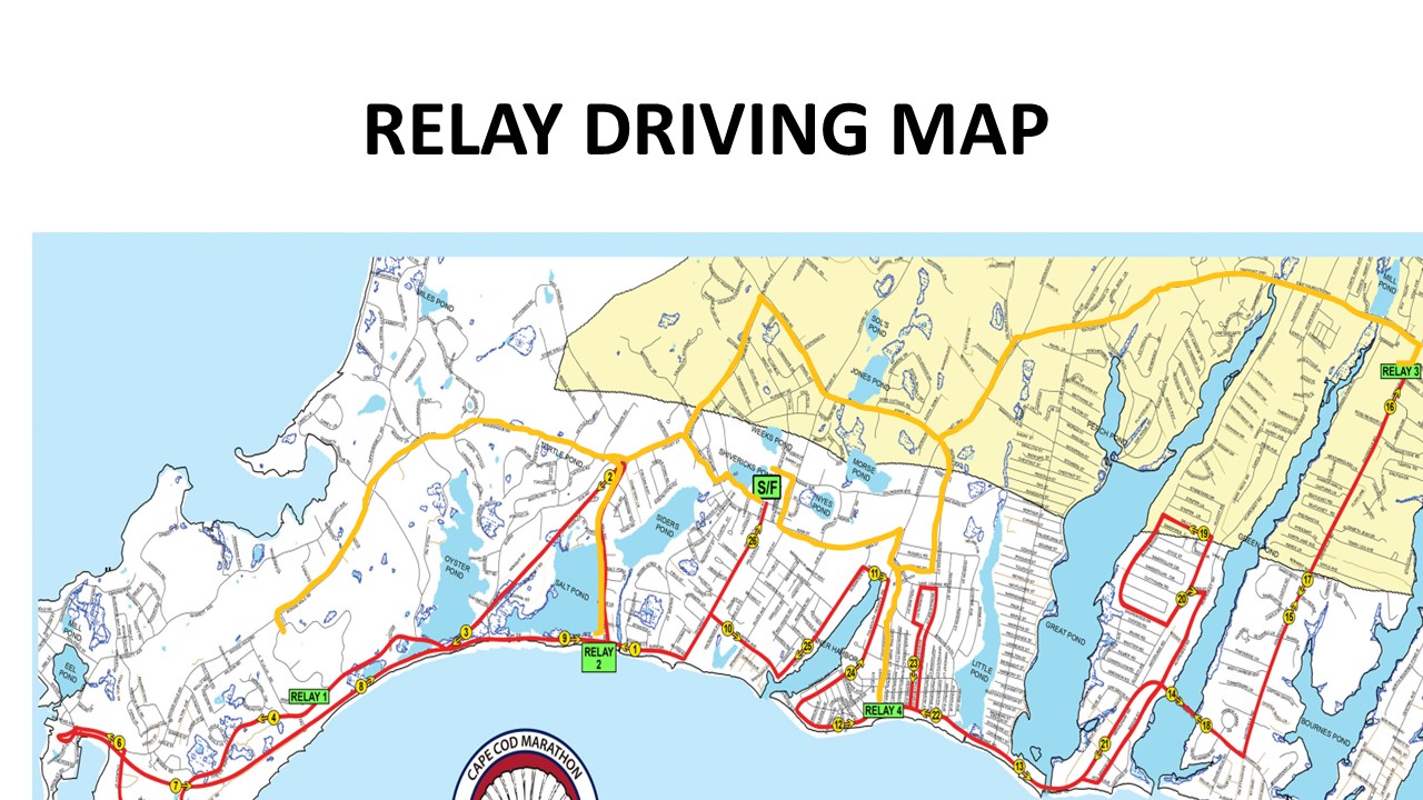
IMPORTANT – FOR THE SAFETY OF ALL RUNNERS, PLEASE DO NOT DRIVE ON THE RACE COURSE.
DO NOT USE YOUR GPS DEVICE TO NAVIGATE, AS IT MAY WANT TO TAKE YOU ONTO THE RACE COURSE (Not a good idea).
Some sections of the course will be closed to vehicle traffic, so if you try to drive on the course, you will probably get stopped and may not make it in time to the next Relay Exchange Zone.
The easiest way to navigate to the Relay Exchange Zones is to follow these instructions and the yellow line on the map in your race packet.
For runner turn-by-turn directions please refer to the Route Map page on the Marathon page.
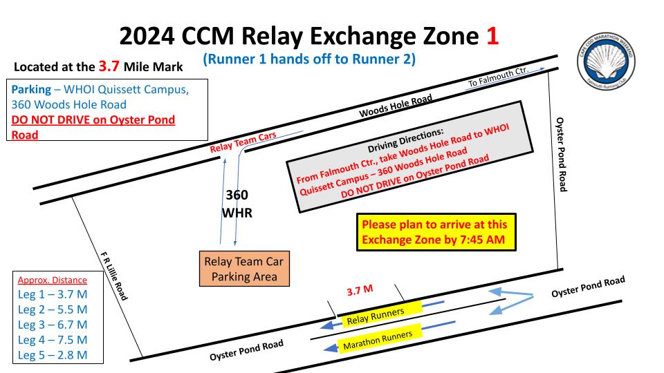
Starting Line Area to Relay Exchange Zone 1 at 360 Woods Hole Road
(2.9 miles, 10 minute drive)
After you have dropped your first runner at the Start Line, plan to have your 2nd runner at Relay Exchange Zone 1 by 87:45 am
From Katherine Lee Bates Road, drive west to Post Office Road.
Turn Left onto Post Office Road
Turn Right onto Main Street
Turn Left onto Locust Street
Locust Street turns into Woods Hole Road
Follow Woods Hole Road to 360 Woods Hole Road
Turn Left into the parking lot and follow the signs for parking
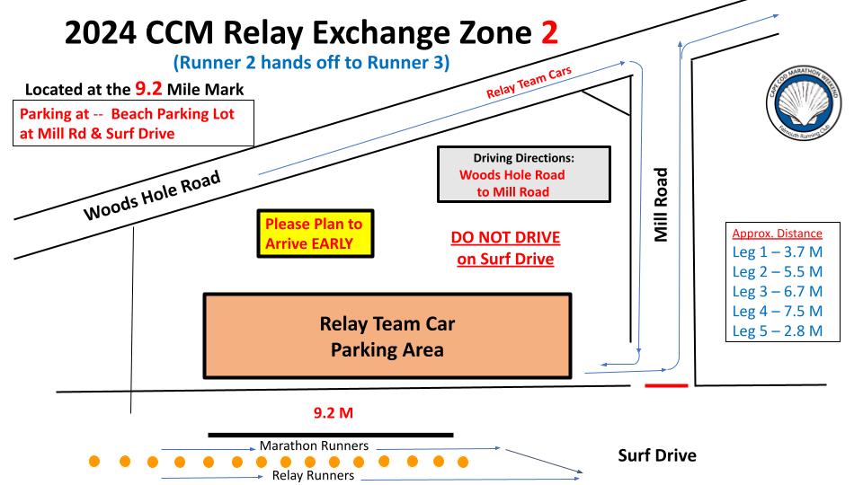
Relay Exchange Zone 1 to Relay Exchange Zone 2 at Mill Road & Surf Drive
(2.8 miles, 6 minute drive)
From 360 Woods Hole Road, turn Right and drive toward Falmouth Green
Turn Right onto Cemetery Lane
Turn Right onto Mill Road
Follow Mill Road to Surf Drive
Park in parking lot at Mill Road & Surf Drive
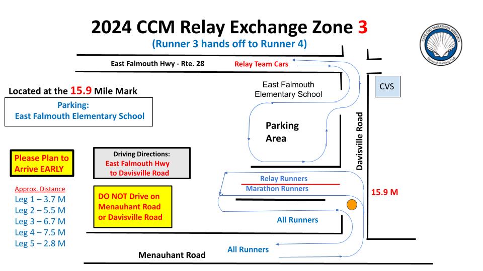
Relay Exchange Zone 2 to Relay Exchange Zone 3 at East Falmouth Elementary School
(5.6 miles, 15 minute drive)
Turn Left out of the parking lot onto Mill Road
Follow Mill Road to Locust Street
Turn Right onto Locust Street
Locust Street turns into Palmer Ave
Follow Palmer Ave to the traffic light at Jones Road
Turn Right onto Jones Road
Follow Jones Road to the second traffic light at Teaticket Highway (Route 28)
Turn Left onto Route 28 (Teaticket Hwy)
Follow Route 28 to the traffic light Davisville Road
Turn Right onto Davisville Road
Turn Right into the East Falmouth Elementary School parking lot
Follow the signs for parking
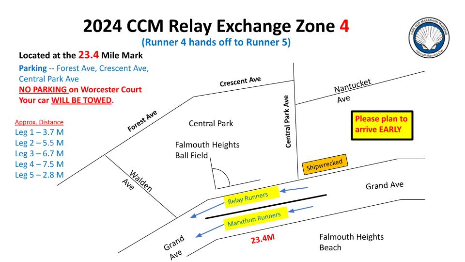
Relay Exchange Zone 3 to Relay Exchange Zone 4
(3.9 miles, 15 minute drive)
Turn Left out of the parking lot onto Davisville Road toward Route 28
At the traffic light turn Left onto Route 28
Follow Route 28 to the traffic light at Worcester Court
Turn Left onto Worcester Court
Turn Right onto Young Road
Bear Left onto Jericho Path (NOT Lake Leaman Road)
Turn Right onto Central Park Court
Follow Central Park Court to the Falmouth Heights ball field
Follow the signs for parking
Relay Exchange Zone 4 to the Finish area
(1.7 miles, 10 minute drive)
From the Ball Field, take Central Park Court to Jericho Path
Bear Left onto Jericho Path
Bear Left onto Lake Leaman Road
Turn Right onto Falmouth Heights Road
Turn Left onto Main Street
Turn Right onto Gifford Street
Turn Left onto Dillingham Ave
Follow Dillingham Ave to parking at Lawrence School
Walk to finish line at Mullen Hall School
Cape Cod Marathon Runner Progression Chart
| Mile | Fastest (5:00/mile) |
Slowest (13:44/mile) |
Location |
|---|---|---|---|
| 0 | 8:00 am | 8:00 am | Start – Mullen-Hall School |
| 1 | 8:05 AM | 8:14 am | Surf Drive at Bywater Court |
| 2 | 8:10 am | 8:27 AM | Shining Sea Bikeway near Locust St. |
| 3 | 8:15 am | 8:41 AM | Shining Sea Bikeway near Surf Drive |
| 4 | 8:20 am | 8:55 AM | Oyster Pond Rd. after F R Lillie Rd |
| 5 | 8:25 am | 9:09 AM | Nobska Rd before Lighthouse Hill |
| 6 | 8:30 am | 9:22 AM | Woods Hole Rd after Church St. (559 Woods Hole Rd) |
| 7 | 8:35 AM | 9:36 AM | Shining Sea Bikeway before Fay Rd. bridge |
| 8 | 8:40 AM | 9:50 AM | Shining Sea Bikeway before Trunk River bridge |
| 9 | 8:45 AM | 10:04 AM | Surf Dr. 100 yds. before FRR 4 Mile Mark |
| 10 | 8:50 AM | 10:17 AM | 155 Clinton Ave. near Timothy Nye Cartway |
| 11 | 8:55 AM | 10:31 AM | Falmouth Heights Rd. at Charr Custom Boat |
| 12 | 9:00 AM | 10:45 AM | Grand Ave. at Walden Ave. |
| 13 | 9:05 AM | 10:58 AM | Menauhant Rd. at end of Great Pond Bridge |
| 13.1 | 9:06 AM | 11:00 AM | After Great Pond Bridge at 196 Menauhant Rd. |
| 14 | 9:10 AM | 11:12 AM | After Green Pond Bridge past Green Harbor Rd. |
| 15 | 9:15 AM | 11:26 AM | Davisville Rd. at Bacon Farm Rd. |
| 16 | 9:20 AM | 11:40 AM | After Relay #3, 91 Davisville Rd before Rose Meadow Rd. |
| 17 | 9:25 AM | 11:54 AM | Davisville Rd. at Seashell & Shaker Lanes |
| 18 | 9:30 AM | 12:07 PM | Acapesket Rd.. just after Menauhant Intersection. |
| 19 | 9:35 AM | 12:21 PM | Shorewood Dr. at Great Harbors Clubhouse |
| 20 | 9:40 AM | 12:35 PM | Acapesket Rd. after House #401 before Boggs St. |
| 21 | 9:45 AM | 12:49 PM | Menauhant Rd. after Beach St. at bridge |
| 22 | 9:50 AM | 1:02 PM | #25 Worcester Ct. (East) before Jericho Path |
| 23 | 9:55 AM | 1:16 PM | #18 Worcester Court (West) after Jericho Path |
| 24 | 10:00 AM | 1:30 PM | Grand Ave. before Black Dog Cafe |
| 25 | 10:05 AM | 1:44 PM | Scranton Ave.at Flying Bridge Restaurant |
| 26 | 10:10 AM | 1:57 PM | Shore St. at Shoreway Acres Inn |
| 26.2 | 10:12 AM | 2:00 PM | Finish — Mullen-Hall School |